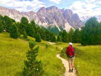
Alta via 2

Also known as: Dolomite High Route 2

Distance: 160 km
Duration: 13 - 17 days
Country:
The Alta Via 2 in the Italian Dolomites offers a trek through some of Europe's most dramatic mountain landscapes, complete with towering limestone spires and serene alpine meadows. The route combines challenging terrain with the comfort of well-placed mountain huts, making it a compelling choice for those seeking both adventure and amenities.

Table of contents

Itinerary
Route
Difficulty

Distances

  • 13 - 17 days, 160 km, +10,000 m, 2,752 m high point
  • daily: 6 - 8 hours, 10 - 15 km, +600 - 800 m gain

Route

  • through hike
  • starting in Bressanone (Brixen)
  • ending in Feltre
Alta Via 2 is a challenging long-distance trek in the Italian Dolomites, offering breathtaking views and alpine experiences. This itinerary covers the entire journey from start to finish.
Day 1

Bressanone to Rifugio Genova (2,297 m)

Distance: 15 kmTime trekking / climbing: 7 hoursElevation change: +1,737 m
Enjoy scenic views and lush landscapes along the way.
Day 2

Rifugio Genova to Rifugio Puez (2,475 m)

Distance: 12 kmTime trekking / climbing: 5 hoursElevation change: +178 m
As you hike towards a mountain pass, you'll cross slopes adorned with colorful wildflowers, offering picturesque vistas of the majestic Odle group sprawled out before you.
Day 3

Rifugio Puez to Rifugio Piscadiu (2,587 m)

Distance: 15 kmTime trekking / climbing: 5 hoursElevation change: +112 m
The journey unfolds as a series of gradual ascents and descents, weaving through forks, rocky outcrops, petite towers, and verdant pastures, culminating at the expansive Dolomite pass known as Passo Gardena.
Day 4

Rifugio Piscadiu to Rifugio Castiglioni Marmolada (2,057 m)

Distance: 17 kmTime trekking / climbing: 7 hoursElevation change: -530 m
The route offers a broad and picturesque view, with the majestic presence of the Marmolada dominating the scenery.
Day 5

Rifugio Castiglioni Marmolada to Rifugio Contrin (2,016 m)

Distance: 11 kmTime trekking / climbing: 4 hoursElevation change: -41 m
Proceed through the woodland towards the village of Penia, and just after passing through the village, make a left ascent towards Val Contrin, following the trail known as "Locia de Contrin," leading to the mountain hut bearing the same name.
Day 6

Rifugio Contrin to Rifugio Cappanna Passo Valles (2,031 m)

Distance: 18 kmTime trekking / climbing: 8 hoursElevation change: +15 m
As you continue your ascent towards the southeast across grassy terrain, you'll eventually come across a ski slope, beyond which you'll encounter the slender meadows of the High Gypsies.
Day 7

Rifugio Cappanna Passo Valles to Rifugio Volpi al Mulaz (2,571 m)

Distance: 8 kmTime trekking / climbing: 4 hoursElevation change: +540 m
Starting at Valles Pass, the trail ascends along a narrow yet clearly defined path leading to the Veneggia Pass.
Day 8

Rifugio Volpi al Mulaz to Rifugio Pedrotti alla Rosetta (2,581 m)

Distance: 7 kmTime trekking / climbing: 4 hoursElevation change: +10 m
The trail descends steeply through meadows, utilizing steel cables for assistance, and eventually leads to Pian dei Cantoni. At this point, near a prominent boulder, you'll find the enchanting Sentiero delle Comelle merging from the left, having originated from Garès.
Day 9

Rifugio Rosetta to Rifugio Treviso (1,631 m)

Distance: 12 kmTime trekking / climbing: 6 hoursElevation change: -950 m
Departing from Rifugio Rosetta, take trail number 702, which leads you into the expansive Val di Roda. On your left, you'll be encompassed by the striking Cime di Roda, Pala di San Martino, and Immink, while on the right, the landscape is dominated by the Cima Val di Roda, adorned with its numerous pinnacles.
Day 10

Rifugio Treviso to Passo Cereda (1,361 m)

Distance: 8 kmTime trekking / climbing: 4 hoursElevation change: -270 m
From Rifugio Treviso, follow path 718 to a grassy clearing called Campigol del Oltro.
Day 11

Passo Cereda to Rifugio Bruno Boz (1,718 m)

Distance: 13 kmTime trekking / climbing: 7 hoursElevation change: +357 m
Upon arriving at the camping area, start your ascent in the southeast direction, following the guidance provided by the hut signs. Once you cross the narrow white road, proceed further southward and enter a picturesque gorge.
Day 12

Rifugio Bruno Boz to Croce d'Aune (1,011 m)

Distance: 19 kmTime trekking / climbing: 9 hoursElevation change: -707 m
The route is easy and gives the opportunity to enjoy the views of the Feltre Valley.

The trek is 5 / 10, based on the below factors:

Terrain & route condition 6 / 10

Treks that involve rugged or uneven terrain, such as rocky paths, scree slopes, or dense forests, may require more technical skills or physical effort.

Altitude / Elevation 4 / 10

Considering the maximum altitude reached during the trek. Higher altitudes can present challenges like thin air, low oxygen levels, and potential altitude sickness.

Distance 7 / 10

The total distance of the trek. Longer treks generally require more endurance and physical fitness.

Elevation gain 6 / 10

Total elevation gain throughout the trek. Treks with significant altitude changes can be more challenging, especially if they involve steep ascents or descents.

Technical difficulty 4 / 10

Some treks may require basic technical skills like river crossings, using ropes, or scrambling over rocks.

Access to facilities / Remoteness 5 / 10

Based on the availability of support facilities such as accommodation, food, water sources, and emergency services. Treks with limited infrastructure or remote areas can be more challenging due to self-sufficiency requirements. The less support facilities there are the harder the trek.

Climate & weather 5 / 10

How tough are the prevailing weather and climate conditions during the trek. Harsh weather, extreme temperatures, or unpredictable conditions can add to the difficulty.